(GR 339 478 )
Directions to point J (GR 341 472)
At the junction of the paths turn right to travel in a southerly direction towards the Hetton –East Rainton road which will come into view once you have walked up the slight rise. After 300 metres take care in crossing the road to continue down a straight track for about half a kilometre. After 150 metres there is an old pit heap on the left. (point I). Continue walking south in the direction of Moorsley until you reach a cross-roads of paths at which point there is a black seat and a fingerpost direction sign. Turn left at the cross-roads and walk along a broad made-up track
Point J QRCode or link to information 
Point I The Hazard Pit was sunk around 1816 and operated from 1818. It was owned initially by a group known as the North Hetton Coal Company. The owners included Lord Durham, Messrs Wood, Philipson, Burrell and others. In 1820 Lady Vane Tempest had shown an interest in owning the pit and within a few years her husband Lord Londonderry had an interest in the pit. The pit was bought by the Hetton Coal Company during the 1840s. In 1915 it merged with Moorsley Colliery to become the North Hetton Colliery and in 1919 it belonged to the Lambton and Hetton Collieries, coal from the colliery was sent along the Londonderry Railway system and on to Seaham Harbour but when this closed in 1896 the coal was diverted to the Hetton Railway and the coal went to the staithes at Sunderland. The headgear for the colliery was originally built of wood and this was not changed to steel until during the first World War. The colliery shaft and engine house were still in evidence until about 1980 and they were removed as part of the reclamation scheme. At the start of the first World war the Hazard Colliery employed over 800 men and boys, probably the greatest level of employment. After this date amalgamation with Moorsley colliery and the joint number employed exceeded 1200 workers in 1921.The Hazard pit finally closed in 1934 along with Moorsley colliery. Some 400 metres to the North of the hazard pit was the Dunwell pit. It appears that this pit may well have been in operation during the last decades of the 18th century and continued until possibly as late as 1830. It was in comparison to the Hazard pit, its close neighbour, a very small pit with most of its coal being sold by landsale via a coal depot half way up the Rainton Bank. It was part of the Londonderry Empire which by 1890 was all but finished in the Rainton area. By the late 1970s the last vestiges of the pit remained( a floor for a stationary engine which had been used to haul empty wagons up a small waggonway from the coal depot situated on the old Durham to Sunderland road.) All remains of the Dunwell pit were removed when the land was reclaimed at the same time as that of the Hazard pit and the railway to Moorsley in the early 1980s.
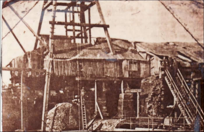 
| This picture of the Hazard Colliery at East Rainton was taken before 1915 and shows the old wooden headgear which was replaced by a steel structure in that year. This colliery provided the main place of employment for most of the men-folk of the village. |
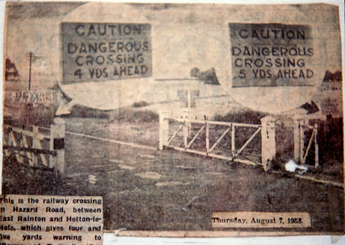
The railway crossing in the picture above was demolished in the 1960s, long after the line became disused. We cross the Hazard Lane at this point |
|